
may contain errors
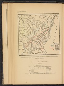
Plate XXVII: Map showing the distribution of Liriodendron Tulipifera
- 1884-Apr – 1887-Jun
Printed map depicts the eastern half of the United States of America with the distribution of Liriodendron Tulipifera, or tulip tree, spanning from the Florida Panhandle west to Arkansas all the way north through Illinois, Michigan, New York and Vermont. Accompanying explanation states how while the plant can be found in northern New York and east of the Hudson River, due to the severe winters the growth can be rare and stunted. In addition, the east coast in the Carolinas and south of Tennessee findings of this plant is also rare and stunted due to unfavorable soil.
| Property | Value |
|---|---|
| Creator of work | |
| Format | |
| Genre | |
| Extent |
|
| Language | |
| Subject | |
| Rights | Public Domain Mark 1.0 |
| Credit line |
|
Institutional location
| Department | |
|---|---|
| Physical container |
|
Related Items


Cite as
Lloyd, C.G. (Curtis Gates), and John Uri Lloyd. “Plate XXVII: Map Showing the Distribution of Liriodendron Tulipifera.” Drugs and Medicines of North America, 1884–1887. https://digital.sciencehistory.org/works/jq085k773.
This citation is automatically generated and may contain errors.
